


LOCHEUR 22K

UDGI54
User
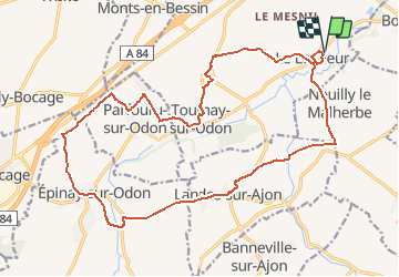

Length
21 km

Max alt
215 m

Uphill gradient
424 m
Km-Effort
26 km

Min alt
58 m

Downhill gradient
426 m
Boucle
Yes
Creation date :
2020-05-20 04:12:41.546
Updated on :
2020-05-20 04:34:43.332
5h53
Difficulty : Very difficult

FREE GPS app for hiking
 SityTrail
IGN / Geographical institutes
SityTrail Plus
The world is yours!
About
Trail Walking of 21 km to be discovered at Normandy, Calvados, Val d'Arry. This trail is proposed by UDGI54.
Positioning
Country:
France
Region :
Normandy
Department/Province :
Calvados
Municipality :
Val d'Arry
Location:
Le Locheur
Start:(Dec)
Start:(UTM)
678889 ; 5442028 (30U) N.
Comments